Putting the UK on the Map
Many of you are probably familiar with the WWW active maps of UK academic resources operated by the University of Wolverhampton's School of Computing and Information Technology. If you're not point your WWW browser at http://www.scit.wlv.ac.uk/ukinfo/uk.map.html before going any further. I thought it might be of interest to Ariadne readers to hear how and why these maps were created. Maps such as these provide a very high density of information in a fairly digestable form, a recent version had well over 200 links to institutions displayed on a single WWW page. This is a much better use of screen "real-estate" than simple text lists.
The history of the maps is closely related to the history of computing and facilities and network connectivity at the University of Wolverhampton. Our first network connection was a PSS link for email only in 1988. In 1988 a proper JANET link running at 9600 baud was provided to the then Polytechnic, this, however, supported only the JANET coloured book protocols. 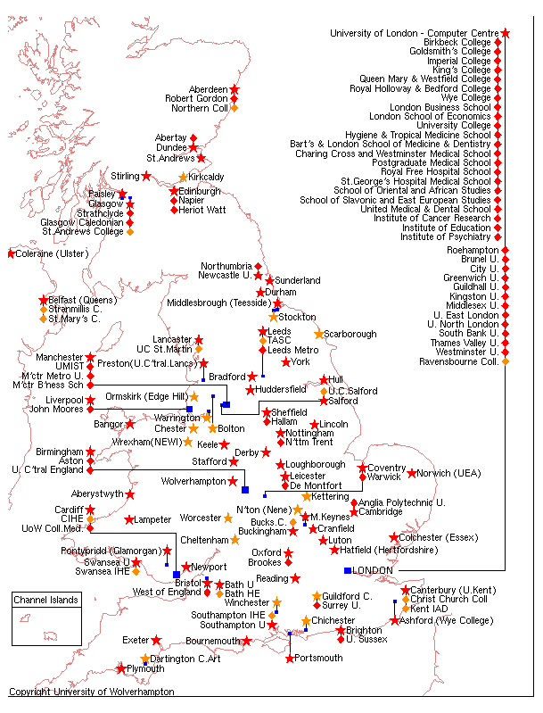 It was not until October 1992, after the School of Computing had purchased SUN workstations in the previous May, that a proper Internet connection was provided initially running at 64 kbaud. At this stage I obtained a modest timetable allowance for keeping the SUN workstations running and installing new software as required. Enthusiasts within the School of Computing quickly discovered the riches available from the numerous anonymous FTP servers that were then the Internet's best public resource. Clients using the "archie" software were quickly installed to help users navigate the Internet's resources.
By the end of 1993 two very significant developments had taken place. I had decided that we ought to give something back to the Internet community in return for all the goodies we had downloaded for free and three separate researchers in the school had separately downloaded and installed a piece of X-windows software called "mosaic" (an early WWW browser). A small sum of money was spent on a collection of CD-ROMs from an American source and I learnt how to run an anonymous FTP archive. An email to the people at Imperial College resulted in details of our archive being included in the "archie" server database, making us the first former Polytechnic to run an "archie" indexed database. I also decided that three copies of "mosaic" was a bit silly and decided to make a regular public installation configured initially to point at the NCSA server and shortly thereafter at the Manchester University server.
There was a large amount of interesting free software to download and install and it was difficult to know what to do next. This work was all undertaken in the context of a general timetable allowance for running the School's SUN workstations and servers.
In April 1994 I attended a student seminar about the application known as "gopher", this was a very well presented seminar and I went away inspired to try and get a "gopher" server running. This took about 2 hours (honest !) and an e-mail to the UKOLN people at Bath resulted in our server being in the national list. Next on the list was WAIS but it looked really rather complicated and I never quite got it sorted out, so instead in May 1994 I decided to install a WWW server. This was rather harder and took about 2 days. An e-mail to Imperial College resulted in our server being included a list they maintained.
We were rather impressed with an active map of UK academic sites available from Edinburgh University, however they didn't seem to have the resources available to support it as requests for inclusion went unanswered. We had already decided to run a day course for industrialists on the Internet and its uses and had decided to provide hands-on experience of the WWW as part of the course and felt that those taking part in the course should see a map that showed Wolverhampton.
So we decided to do our own map. I had already done a simple active map of South Shropshire so this didn't seem too difficult a task however a good quality outline map of the UK didn't seem to be readily available. Scanned images were felt to be rather tatty. Fortunately about 20 years ago I had written out (on punched cards) the outline of British Isles as a series of X-Y coordinates using the National Grid system and this file was still available. However, not being a computer graphics expert, I was unsure how to convert this into an image and even if I could do that there was a requirement to annotate the image with place names etc.
So I decided to learn about Postscript. We had the excellent public domain "ghostview" PostScript viewer and it proved not too difficult to convert the data file into a long sequence of "moveto" commands which drew lines. The annotation was a bit more tricky and PostScript functions were written to draw red stars (for WWW servers) and green triangles (for gopher servers) as well as lines and text positioning. This all worked surprisingly well and I would recommend direct PostScript coding to any-body who wants to create a good quality line image from coordinate data. The WWW, however, required a GIF image, this was easily generated by using the excellent public domain "xv" image viewing program to grab the "ghostview" screen image. The X-Y co-ordinates for the hot spots were also determined using "xv".
When this was all done and the necessary files had been created and installed we were ready to go. The map went live in July 1994 and a note about it was posted to one of the newsgroups. By coincidence Edinburgh stopped serving their map at about the same time. Email to Geneva resulted in our map being included in the lists they maintained and the people at Boulder, Colorado who support the world active maps found out about it anyway.
The map had initially been drawn to show all UK universities even though they didn't at that time have Internet connectivity or a WWW server. The last to come on line was Glasgow Caledonian in February 1996. In order to support our course we had also prepared a classified list of UK WWW resources, this quickly suggested that maps showing research and commercial sites would be useful. It should be remembered that at this time (July 1994) there were probably no more than 200-300 WWW sites in the UK. Research and commercial maps were quickly prepared using the same techniques. Reflection suggested that the commercial map was of very limited use as people look for commercial organisations based on what they do rather than where they are located so it was dropped and effort put into a fully classified searchable listing of UK WWW sites using Dewey Decimal coding, however that is another story.
It was always our intention to show all academic sites rather than just universities and it was also necessary to keep the maps up-to-date as new sites appeared. Detection of new sites is done in a variety of informal ways, nowadays new sites often send us an e-mail requesting inclusion on the map but when we started examination of the access log was often the first indication of a new institution coming on-line. We also examine the DNS domain listings from time to time. The first non-university sites were University College, Salford and Aberdeen's Northern College.
The course which had motivated me to produce the map was now long past but I still had the allowance for running the system and the map seemed useful so I decided to keep it going with updates every 1-2 months as time permitted. I had several e-mail correspondences about the precise names of institutions (it's Middlesbrough NOT Middlesborough !) and their precise locations. Somebody complained that I had put all the London sites in the middle of the North Sea but didn't suggest a viable alternative strategy for showing this congested area. Congestion was getting serious, especially in the Manchester area, and it was getting quite hard work to shoe horn in new sites with correct annotation. I'm still dreading e-mail from the Central Gloucestershire and Cheltenham Collegiate Institution for Agricultural Technological Education whose name MUST appear in full.
In early 1996 I decided on a major rework of the map to make it clearer what sort of institution a link pointed to. To this end I used diamonds and stars (the last of the "gopher" triangles had long gone) to distinguish place names from institution names and different colours to distinguish types of institution. These were red for a university, orange for a university sector college, yellow for an FE college and green for a school. This was effective although one correspondent said it looked like an explosion in a Smartie factory. A similar colour scheme was used on the research map to show affiliations of research sites.
At this stage some less obvious changes were also made. We had installed an access counter in June 1995 and this was ticking merrily up to the half million but apart from complicated analysis of the main WWW server log we had no idea which sites people were accessing. The standard NCSA server map software was also noted as being a bit clumsy interpreting a large text file for every query. I decided to write a "bespoke" backend that did not use the NCSA imagemap facilities, instead depending on the CGI interface. The site information is hard-wired into the back end which also logs every access with details of the site accessed. This proved rather straightforward to write although some of the support software that tied the site list to our main database of WWW sites and prepared the associated alphabetical listing of sites was more tricky.
So what are the most popular sites. Here's the top 10 from our very own University League table with accesses from May 16th to September 4th 1996:
| Oxford | 4481 |
| Cambridge | 3749 |
| Edinburgh | 3614 |
| Manchester | 2454 |
| London | 2424 |
| Glasgow | 1894 |
| Leeds | 1837 |
| Sheffield | 1792 |
| Imperial Coll | 1758 |
| Aberdeen | 1744 |
And who uses the map. Of the 148574 accesses between May 16th and September 5th 1996 the following domains stand out:
| UK academic (.ac.uk) | 59703 |
| Germany (.de) | 11949 |
| General commercial (.com) | 11256 |
| UK commercial (.co.uk) | 6591 |
| Netherlands (.nl) | 3863 |
| US Educational (.edu) | 2508 |
| France (.fr) | 1689 |
More recently the academic map has been split into two, one for universities and university sector colleges and one for other colleges with the source of funding being the deciding criterion.
The map is still an unfunded activity, future plans include a further map for schools and the availability of the map and support/logging software as a licensed package for anybody who wants it. The latter should be available, for Unix systems, by the time this appears in print. The positioning of annotation on the maps is still a manual activity requiring editing of a PostScript text file. This can be rather tedious and sometimes updates get "out of phase" with the main map resulting in links going to odd places. There does not seem to be any realistic way of automating map preparation. Our publicity department is waiting for the millionth access, due early 1997, with bated breath.